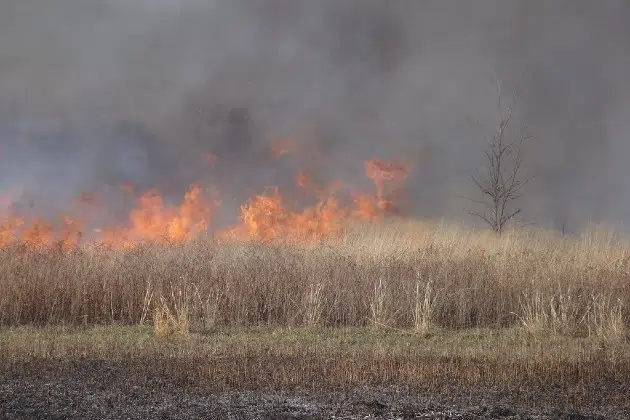
(KNSI) — A Red Flag Warning is in effect for portions of central Minnesota from noon today until 8:00 p.m., as dangerous fire weather conditions are expected this afternoon.
The National Weather Service says a combination of dry fuels, low humidity, and gusty winds will create critical fire conditions. Relative humidity is expected to drop below 30% by early afternoon and could fall as low as 15 to 20% in some areas. Southerly winds of 15 to 25 miles per hour, with gusts of 30 to 35 miles per hour, are forecast across central Minnesota, with the strongest winds and lowest humidity in the mid- to late-afternoon hours.
Officials are urging people to avoid all burning today. Any fire that starts could spread rapidly and become difficult to control.
After a fire weather day on Wednesday, attention turns to a severe storm threat on Thursday afternoon and evening, but mostly to the south. Right now, the St. Cloud area is in a marginal, or one out of five, risk for severe storms.
The National Weather Service says storms are expected to develop across south central Minnesota and push east through the afternoon and evening. That area is in a slight, or two out of five, risk. Damaging winds are the primary threat, with gusts of 60 miles per hour or more possible as storms organize into line segments. Golf ball-size hail is possible early in the event, mainly across southwestern Minnesota. An isolated tornado cannot be ruled out, particularly early on when storms are more isolated.
Heavy rainfall is also a concern, with localized totals of 1″ to 1.5″ possible, mainly across eastern Minnesota. Residents are encouraged to monitor forecasts and have a way to receive weather warnings.
___
Copyright © 2026 Leighton Media. All rights reserved. This material may not be broadcast, published, redistributed, or rewritten, in any way without consent.


FOLLOW US FOR INSTANT UPDATES!


FOLLOW US FOR INSTANT UPDATES!