×

When every second counts, having the right information can make all the difference. But when information is spread across different systems, teams, and locations, getting a clear picture of what’s happening can be difficult — and delays can have serious consequences.

To add to the complexity, organizations generate more data than ever. Drones stream live video, sensors monitor equipment and infrastructure, and GPS systems track people and vehicles in real time. Weather feeds, intelligence reports, and field observations all add to the information flow. The challenge is no longer collecting data but making sense of it.
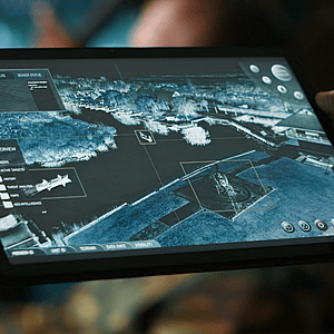
To solve that problem, many organizations rely on what’s known as a common operating picture (COP), which is a single dashboard that combines information from many sources into one shared view. This allows everyone involved to see the same situation at the same time.

For defense organizations, this capability can be especially important. When information from drones, sensors, intelligence systems, and personnel in the field comes together, commanders can better understand changing conditions and coordinate their next moves.

In this article, MAG Aerospace explores how COP is changing the defense landscape.

The Problem: Too Much Information, Not Enough Clarity

Today, the global operational landscape is defined by vast streams of unstructured data, rapidly shifting geopolitical supply chains, and the deep integration of artificial intelligence into daily workflows. Organizations that operate without a common operating picture may experience a “hidden tax” of wasted time searching for updates, working with outdated information, or trying to piece together different versions of the same situation. This hidden tax shows up in the form of delayed emergency responses, supply chain issues and lost battlefield awareness. Sharing a unified knowledge base across organizations, departments, or jurisdictions allows teams to plan collaboratively and efficiently, ensuring everyone shares the same situational awareness at any given time.

From Collecting Data to Understanding the Situation

The concept of a common operating picture has grown beyond its traditional military roots to become a tool for any operation where clear, timely decisions matter. Historically, information during a crisis or complex operation swung between an overwhelming, unmanageable flood of raw data on one side and not enough reliable information to understand what’s happening on the other. Organizational structures, rigorous training protocols, and legacy technologies all struggled to generate an accurate, complete, and current picture of the situation.

The COP solves this by combining information from various sources to create a complete picture. The data collected is well-analyzed and helps teams focus attention and resources where it will make the most difference.

This technology can help shift strategies from passive data monitoring to active situational intelligence, helping teams identify potential problems earlier and make informed decisions before small issues become bigger ones.

What Is a Common Operating Picture?

The concept of the common operating picture can serve as the central nervous system of any high-stakes operation.

A common operating picture is a tool for achieving decision superiority in modern military, government, and commercial operations. By fusing multi-domain intelligence, mapping systems, and real-time sensor data into a single, cohesive interface, a COP can reduce cognitive overload and accelerate the Observe-Orient-Decide-Act (OODA) loop —a decision-making framework that allows leaders to make fast, accurate decisions under pressure.

Through the integration of agentic artificial intelligence, zero trust architectures to prevent hacking, and standardized messaging protocols like Cursor on Target, organizations can transform fragmented data into unified, actionable intelligence for frontline operators. This establishes a head start over the enemy, allowing scattered units to achieve information superiority and make clear decisions at the speed of relevance. Modern COP solutions rely heavily on an “ontological data fabric.” This means if an enemy asset is simultaneously detected by a maritime radar, an airborne drone, and a cyber sensor, the system automatically connects the dots. Instead of cluttering the screens with three separate anomalies, it resolves them into a single, highly accurate track on the map. While a live map can show what’s happening right now, such as the location of a drone or the movement of personnel in the field, a true COP goes much deeper than just tracking immediate chaos. It takes that live, frantic data and blends it with long-term, big-picture information. For instance, a defense dashboard doesn’t just show a live map of a battlefield; it simultaneously tracks warehouse supply levels, troop exhaustion metrics, and regional weather patterns. This allows leaders to do two things at once: Handle an immediate, local threat while ensuring they don’t run out of fuel, food, or ammunition next week.

How Does a Common Operating Picture Differ From a Common Tactical Picture (CTP)?

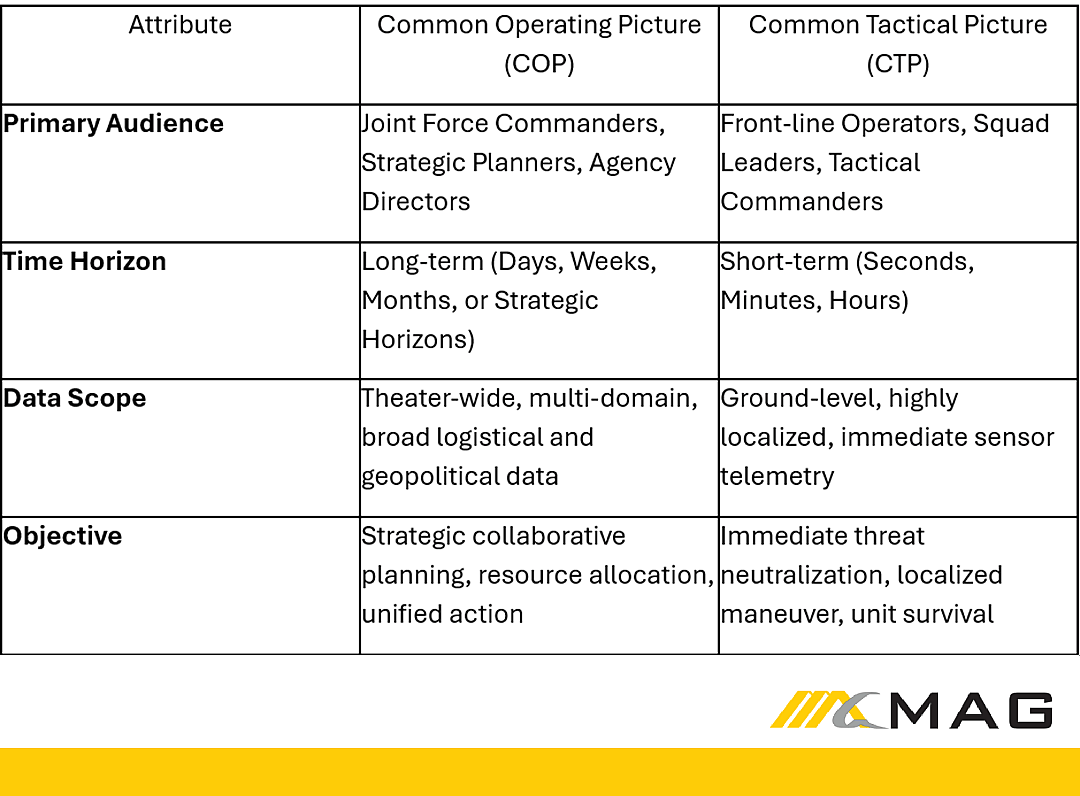
While both systems provide situational awareness, a COP delivers a strategic, long-term view of a theater or incident, whereas a common tactical picture (CTP) focuses on short-term, ground-level operational data.

To maintain decision superiority, organizations must systematically differentiate between the big-picture view of a COP and the detailed, high-resolution localized view of a CTP. The CTP is typically utilized by front-line operators who need immediate, high-resolution data on imminent threats. In contrast, the COP aggregates multiple CTPs, fusing them with data possessing longer lifespans, such as regional logistics, theater-wide supply levels, and geopolitical intelligence.

Comparison table of the attributes of Common Operating Procedure and Common Tactical Picture.
MAG Aerospace

The Data Behind the Picture

A common operating picture is highly customizable, meaning it can pull in almost any type of information based on a user’s requirements. This data can come from official government networks, digital mapping systems, satellite imagery, aerial photos, and live weather reports. Inputs don’t have to be automated either, as COPs can also be generated from manual inputs, such as reports or observations made by field personnel.

To give leaders an instant look at an emergency as it unfolds, COPs use real-time data streams for immediate situational awareness. For example, streaming live video from drones or other surveillance aircraft can provide a real-time view of the operation or incident in progress. Alternatively, data feeds from cellphone towers or other network infrastructure can be used to track the movement of teams on the ground.

By combining real-time data with historical records into a single screen, operational teams gain a powerful tool for understanding their environment to handle short-term and long-term situations effectively.

Why is a Common Operating Picture Essential for Joint All-Domain Command and Control (JADC2)?

A common operating picture is the technological and operational centerpiece of the Department of Defense’s Joint All-Domain Command and Control (JADC2) strategy, enabling forces to seamlessly link sensors to shooters across the land, air, sea, space, and cyberspace domains. The real-time common operating picture helps modern forces execute converged, multi-domain operations at the scale and speed required to defeat near-peer adversaries.

The DoD’s JADC2 strategy envisions a system-of-systems network that completely integrates Command, Control, Communications, Computers, Cyber, Intelligence, Surveillance, and Reconnaissance (C5ISR) capabilities. Architecturally, data streams from sensors across land, air, sea, space, and cyber domains flow into a centralized artificial intelligence data fusion layer, which then distributes actionable intelligence outward to joint force command centers and tactical edge effectors.

Since modern military operations often involve information coming from different services, sensors, and platforms, the JADC2 effort aims to connect those sources and help military forces share information across the Air Force, Army, Marine Corps, Navy, and Space Force, creating a clearer picture of the battlefield.

True JADC2 implementation requires the dismantling of domain-specific, stovepiped networks in favor of a unified data mesh. This infrastructure allows data collected from any intelligence, surveillance, and reconnaissance (ISR) asset to be absorbed, correlated, and acted upon by the platform best positioned to respond, creating a web of effects that overwhelms adversary defenses.

This was tested in initiatives like Project Convergence, where the military demonstrated how powerful a shared live map can be. By integrating data from multiple sensors, including drones, directly into the common operational picture, commanders could use that information to connect weapons with enemy locations. Most importantly, it allowed different military branches to work as one team. As an example, an Air Force drone could spot a target and instantly feed those coordinates to an Army missile launcher on the ground, destroying the threat in seconds.

This interconnected network works whether troops are riding in armored vehicles or operating on foot. By moving this software into a secure cloud environment, soldiers can access a live, mobile version of the map on tablets or handheld devices. Deployed as part of the Mounted Mission Command–Software (MMC-S) program, the system is flexible enough to connect to any available network, from tactical military radios to standard Wi-Fi. Most importantly, by giving everyone from top commanders to infantry squads the exact same real-time view of friendly troop locations, this shared picture can reduce the risk of tragic friendly-fire accidents.

How Does a Common Operating Picture Mitigate Cognitive Overload and Accelerate the OODA Loop?

A COP mitigates cognitive overload by utilizing artificial intelligence to fuse hundreds of disjointed sensor feeds into a single, prioritized visual interface, dramatically reducing the time it takes an operator to complete the OODA loop.

In complex environments—such as counter-unmanned aircraft systems (C-UAS) operations or multi-domain combat—operators face a barrage of incoming data. A human operator cannot manually assess hundreds of inbound tracks, project trajectory impact points, evaluate risk matrices, and allocate kinetic intercepts within a decision window of seconds to minutes. Organizations clinging to disjointed, traditional tools can quickly find themselves in a “dashboard graveyard,” where cognitive collapse can occur because a user is forced to fight the interface rather than the enemy.

The integration of agentic decision support systems into the common operating picture transitions the operator’s role from a raw data processor to a strategic decision-maker. This preserves the essential “human-in-the-loop” model while vastly accelerating decision velocity through the automation of the orientation and observation phases.

Beyond the Battlefield: How COP is Used in Other Industries

Information is the absolute lifeblood of emergency response. During a crisis, information flow can swing wildly between an overwhelming, unmanageable flood of noise and a lack of actionable facts. For emergency responders, a common operating picture is so critical that the Federal Emergency Management Agency (FEMA) explicitly mandates its use through the National Incident Management System (NIMS).

Hurricane Katrina exposed the challenges of coordinating a large-scale disaster response across multiple agencies. Although the NIMS was developed in the years before the storm, the 2005 response was hampered by communication breakdowns, unclear responsibilities, and gaps in situational awareness. Government reports later recommended a national information system to provide a single, shared view of the disaster.

Emergency Management: Saving Lives in the “First 100 Minutes”

Today, that lesson has transformed how cities handle the critical “first 100 minutes” of a disaster—like a chemical spill or a severe explosion. Federal guidance from the Department of Homeland Security warns that a poorly coordinated response during the “first 100 minutes” of a radiological dispersal device directly threatens lives. Long before highly specialized state and federal teams—such as the Aerial Measuring System or the National Guard Civil Support Team—arrive on scene, local first responders must rapidly establish a common operating picture to map out danger zones, track first responder locations, and issue targeted evacuation notices from a single screen. Combining this live data ensures that everyone from the local police chief to the governor is working from the exact same view when every second counts.

Business and Infrastructure: COP’s Role in Fixing Hidden Bottlenecks

While common operating pictures have traditionally been associated with combat operations and disaster relief, they are equally important for running global businesses and protecting everyday infrastructure.

In the current era of “Supply Chain 3.0,” geopolitics, tariffs, and rapidly evolving economies are driving the most significant global restructuring in a generation. However, despite heavy investments in digital strategy, the 2026 EFESO Global Supply Chain Survey reveals that only 31% of global companies report having full, end-to-end supply chain visibility.

A corporate COP can give companies a massive competitive advantage. By putting their entire global operation onto a single screen, leaders can visually track shipping containers, monitor delivery fleets, and spot a bottleneck at a port days before it causes a shortage on store shelves, enabling real-time visibility and control.

Utilities: Keeping the Lights On

A prime example of commercial COP in action is the Hull Municipal Light Plant in Massachusetts. Prior to upgrading, staff lacked a COP, relying heavily on outdated paper forms and disconnected computer files, which often required staff to perform duplicate work, interpreting field data.

By establishing a COP, the utility improved its data integrity by 80% and enhanced its decision-making efficiency by 25%. Today, if a storm knocks out a power line, crews don’t have to guess where the break is. They can instantly see the exact status of the grid on one screen, trace the issue, and get the power back on faster and cheaper for their customers.

Artificial Intelligence’s Role in the Common Operating Picture

As of 2026, any serious discourse surrounding the common operating picture is inextricably linked to artificial intelligence and machine learning (ML). Because modern drones, sensors, and global supply chains generate a mountain of information, it is impossible for a human brain to process it all. AI is no longer viewed as an experimental concept; it is the core component required to extract the most important facts from the deafening noise of an increasingly cluttered information environment.

From Watching to Predicting

Legacy COPs required humans to look at a screen, spot a problem, and figure out a solution. Today, AI agents play a significantly larger role in daily operations, acting more like autonomous teammates than mere software tools.

In military and public safety settings, advanced AI algorithms can instantly run thousands of “what-if” scenarios—similar to a high-speed chess computer—to test different choices before they are made. This technological leap allows human analysts to spend their limited time on high-level strategic decision-making, rather than spending hours painstakingly sorting through raw data.

What are the Core Components Required to Build a Next-Generation Common Operating Picture?

Building a next-generation common operating picture requires migrating away from bespoke, single-vendor dashboard displays toward an open, interoperable, and AI-enabled data ecosystem. The most effective systems universally share three core technical building blocks.

1. Multi-Domain Sensor Integration

A robust common operating picture requires the technical capacity to ingest unstructured and structured data from across all domains. This includes satellite imagery, aerial surveillance, signals intelligence (SIGINT), radar tracks, ground-based IoT sensors, and open-source weather data. The system must utilize standardized data formats (such as Cursor on Target and MIL-STD-2525) to prevent vendor lock-in and ensure plug-and-play compatibility with future sensor technologies.

2. A Cloud-Native, Ontological Data Fabric

To prevent the COP from becoming a repository of static visualizations, the underlying architecture must feature a centralized data fabric grounded in a shared data language. This shared foundation ensures that data is contextualized; the system inherently understands the relationship between different assets, allowing artificial intelligence models to rapidly prioritize threats and automatically generate distinct courses of action for commanders.

3. Edge Computing and Artificial Intelligence

When communications are down or unstable, front-line units cannot rely on communicating with remote home-base data centers. Next-generation systems embed AI and edge computing hardware directly within frontline units—within vehicles, aircraft, and dismounted kits. Edge AI handles local processing, exploitation, and dissemination (PED), analyzing massive volumes of raw sensor data locally and only transmitting the most important insights to the broader network, preserving vital bandwidth.

Transforming Chaos Into Control

From military battlefields to city streets and corporate boardrooms, a common operating picture is no longer just a high-tech luxury—it can be critical for any operation. In a world drowning in data, organizations that successfully build a single, shared view of reality can see dramatic drops in response times and massive improvements in accuracy.

To unlock these benefits, executive leaders must treat the common operating picture not merely as a standalone software purchase, but as a culture shift where data is openly shared across departments and agencies.

By embracing a COP with clean data and fostering a culture of transparency and collaboration, organizations can transform the overwhelming chaos of the modern information environment into more structured, actionable control.

This story was produced by MAG Aerospace and reviewed and distributed by Stacker.