
UPDATE: 6:50 — The National Weather Service has issued a Severe Thunderstorm Warning for…Central Wright County, Eastern Benton, Sherburne County, and East-central Stearns County in central Minnesota until 7:15 p.m. At 6:40 severe thunderstorms were located along a line extending from Waite Park to Monticello to near Corcoran, moving northeast at 65 mph.
Golf ball size hail and 70 mph wind gusts were reported. People and animals outdoors will be injured. Expect hail
damage to roofs, siding, windows, and vehicles. Expect considerable tree damage. Wind damage is also likely to
mobile homes, roofs, and outbuildings.
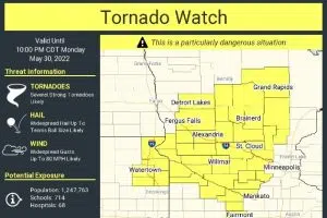
(KNSI) — The National Weather Service has issued a tornado watch that includes the St. Cloud area.
The tornado watch for Benton, Kandiyohi, Meeker, Morrison, Sherburne, Stearns, Todd, and Wright Counties is until 10:00 p.m. Primary threats include several tornadoes and a few intense tornadoes likely, widespread damaging winds, and scattered significant gusts to 80 miles an hour are likely, and widespread large hail and scattered hail up to 2.5 inches in diameter.
National Weather Service
A tornado watch means conditions are favorable for tornadoes and severe thunderstorms in and close to the watch area. If a warning is issued for your area, move to a place of safety, ideally in an interior room on the lowest floor of a sturdy building.
The Storm Prediction Center has issued a public severe weather outlook for our area with powerful wording explaining the setup will “support intense rotation with any discrete or line-embedded supercells, and a couple of significant tornadoes will be possible into the early evening.”
The particularly dangerous situation tag does not get used very often for storms around Minnesota. It is also rare to see high probabilities for every hazard, including strong tornadoes. Forecasters have attached both for this watch.
Have a way to get warnings for the next several hours.
___
Copyright 2022 Leighton Enterprises, Inc. All rights reserved. This material may not be broadcast, published, redistributed, or rewritten, in any way without consent.
 (1)")

FOLLOW US FOR INSTANT UPDATES!


FOLLOW US FOR INSTANT UPDATES!