Originally published 6:00 a.m. May 12th, 2022
Updated 10:58 a.m. May 12th, 2022
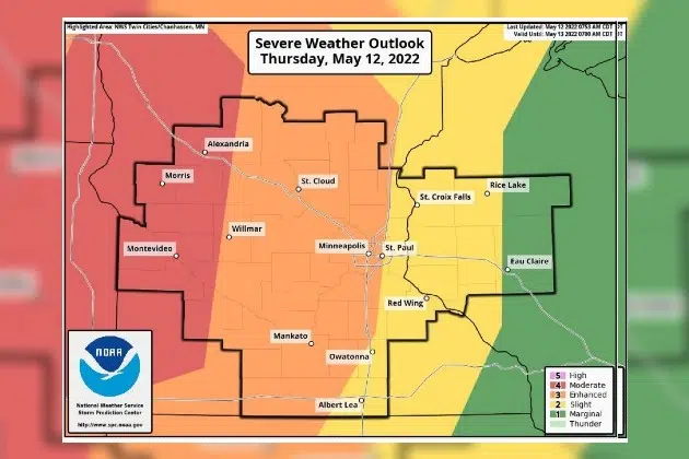
(KNSI) — Central Minnesota is in the enhanced and moderate risk category for severe weather again Thursday after a wild Wednesday afternoon and evening of severe storms.
The Storm Prediction Center has increased the likelihood of severe weather just to the west of St. Cloud, placing it in the moderate risk category or 80 percent chance. That includes western Stearns County also portions of Todd and Kandiyohi County.
Severe storms rumbled through early Thursday morning, prompting warnings and special weather statements for half dollar sized hail and winds around 50 miles an hour. Numerous severe storms are expected to pop back up Thursday afternoon with all modes of severe weather, including tornadoes, very large hail, and widespread wind damage. The saturated ground and forecast high winds with these severe storms can easily topple trees. On Wednesday, the official total for rainfall in the St. Cloud area was 1.61″, which is just short of the record 1.72″ set in 1937.
Heavy rains have been falling over the same area for the last day, leading to localized flooding concerns for Thursday. Wednesday night, flash flooding caused some drivers to become stranded. Manhole covers were also seen popping due to heavy rain.
More than 70,000 Xcel Energy customers were without power after the storms Wednesday afternoon and evening.
Cooler, drier air moves in behind this system with sunshine and temps in the 70s for the weekend.
___
Copyright 2022 Leighton Enterprises, Inc. All rights reserved. This material may not be broadcast, published, redistributed, or rewritten, in any way without consent.


