(KNSI) — Record high temps, rain, severe thunderstorms, tornadoes, and even snow are all in play for Minnesota weather today.
Meteorologist Paige Marten with the National Weather Service says we have never seen a moderate risk of severe weather this late in the year in Minnesota before. She says a moderate risk of severe weather in the summer is a rarity, “let alone nine days before Christmas.”
She says the National Weather Service Forecast Office in Chanhassen, where she is based, has never issued any tornado or severe thunderstorm watches or warnings in December. She says November there have been one or two, but for a state that saw over a foot and a half of snow in some areas this past Friday, “it really is unprescendented.”
Marten explains that the setup started Wednesday morning with a deep low pressure over the state. The official barometric pressure reading for the area was 969 millibars or 28.61 inches. The previous record was 980 millibars or 28.94 inches. The average for the area is 1011 millibars or 29.85 inches. Highs in the southeastern part of the state where most of the severe weather is expected could get into the low 60s Wednesday afternoon. That, in combination with gulf moisture riding on strong southerly winds clashing with wind coming in from the northwest with a powerful cold front, is a recipe for a “rather unstable atmosphere.”
The main widespread hazards today Marten says will be damaging winds. “There is a threat for a few tornadoes, but in terms of affecting the larger, greater area would be damaging winds between 30 to 40 miles an hour, gusting as high as 60 miles an hour.” For severe thunderstorm warnings in the summer, she says the threshold is less than 60 miles an hour, so it’s “an impressively strong wind we’re expecting later this evening.” The line of thunderstorms could contain wind gusts over 80 miles an hour across southern and eastern Minnesota.
She says timing on the system is expected around 4:00 or 5:00 Wednesday afternoon, but gusty winds will remain overnight.
Once storms begin to fire up, she says they will be moving very quickly, so have a way to get warnings and be ready should power be knocked out. After the system moves through, she says temps will plummet into the teens and 20s, so “have a backup plan for being warm.”
Marten says the high winds could also affect driving later today and tonight for those in high profile vehicles like semi trucks or buses. If you’re out and about, she says, “Give them more space on the road. Don’t pass someone if you’re if it’s too windy. Just kind of some general things that thinking outside of the box what you can do to be prepared.”
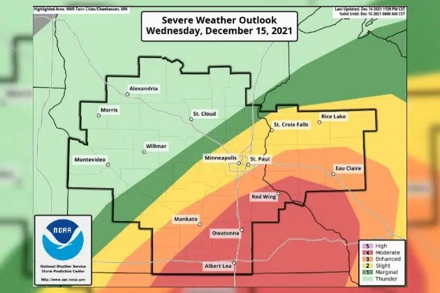
As of the latest model update, the St. Cloud area is under a marginal risk for Wednesday. The farther east, the greater the chance for heavy severe weather, including Faribault, Owatonna, and Rochester. Any tornado spinups will be hard to see as the heaviest weather is expected after dark. The northwestern parts of the state are under a winter weather advisory starting at 7:00 p.m. Wednesday night.
___
Copyright 2021 Leighton Enterprises, Inc. All rights reserved. This material may not be broadcast, published, redistributed, or rewritten, in any way without consent.


FOLLOW US FOR INSTANT UPDATES!


FOLLOW US FOR INSTANT UPDATES!