×

The%20green%20line%20is%20active%20through%20downtown%20Minneapolis%20on%20Tuesday%2C%20Dec.%205.%20

Doesn’t it seem less snowy than normal this winter?

You might be surprised to hear that our official Twin Cities snowfall total is running 3.7 inches above normal for this snow season, which started in October. We did start out very strong, with 9.3 inches of snow tallied at MSP airport in October and 8.8 inches in November. However, from Dec. 1 through Jan. 21 our Twin Cities snowfall has run 4.5 inches below normal. We’ll erase most or all of that near-term snow deficit this weekend.

Let’s start with our current Minnesota snow depth map, courtesy of the Minnesota State Climatology Office:

rt0122snowd
Thursday snow depths
Minnesota State Climatology Office/Minnesota DNR

4 to 8 inch snow depths are reported from the Twin Cities metro area through much of Minnesota. 8 to 12 inch snow depths stretch from the northern edge of the Twin Cities metro area through much of north-central and northeastern Minnesota. Portions of northeastern Minnesota have between 12 inches and 18 inches of snow cover.

Saturday/Saturday night snow

Snow is expected to spread across much of Minnesota and Wisconsin as we go through Saturday. The snow lingers through Saturday evening in most areas, then it tapers off from west to east later Saturday night.

The snow begins in southwestern Minnesota Saturday morning. The snow is expected to arrive in the Twin Cities metro area early Saturday afternoon. The National Oceanic and Atmospheric Administration’s North American Mesoscale (NAM) forecast model shows the potential precipitation pattern from noon on Saturday through noon on Sunday:

rt0122rad3
Simulated radar from noon Saturday through noon on Sunday
NOAA, via Tropicaltidbits.com

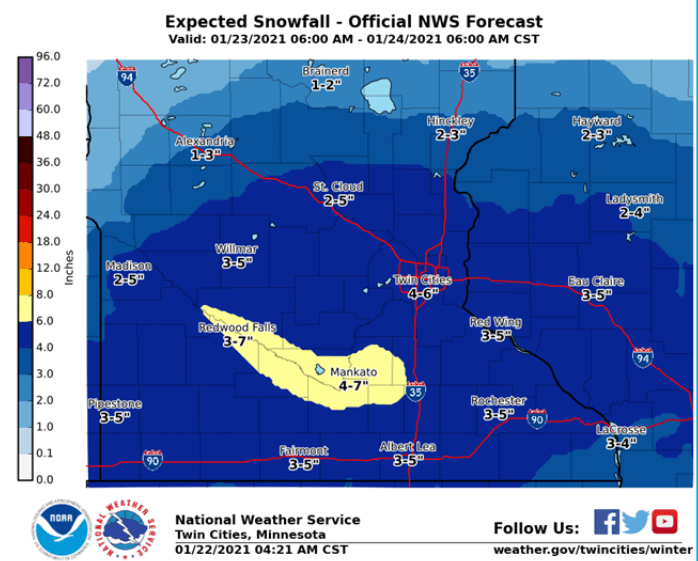
Forecast snow amounts are highest to the south. The yellow-shaded area on this NWS forecast map will have the best chance of seeing 6 or more inches of snow:

rt0122sno
Weekend snow forecast
National Weather Service

4 to 6 inch snow totals seem reasonable for the Twin Cities metro area by the time the snow tapers off late Saturday night.

A winter weather advisory begins Saturday morning and runs through Saturday evening in southwestern Minnesota. A winter storm watch begins Saturday morning for several counties along the Minnesota River in southwestern Minnesota, and the winter storm watch starts at noon Saturday for Mankato and several counties to the east of Mankato:

rt0122adv2
Saturday watches and advisories
National Weather Service

Here are details of the Winter storm watch:

URGENT – WINTER WEATHER MESSAGE National Weather Service Twin Cities/Chanhassen MN 241 AM CST Fri Jan 22 2021 …SEVERAL INCHES OF SNOW EXPECTED SATURDAY INTO SATURDAY NIGHT… .Snow will spread into western Minnesota Saturday morning and reach eastern Minnesota early Saturday afternoon. The snow will end Saturday night. A band of 4 to 7 inches of snow is expected from west central Minnesota down through Redwood Falls, New Ulm, Mankato, down toward Owatonna in southeast Minnesota. Winds will be fairly light, out of the southeast at around 10 mph, and temperatures will near 20 degrees. Snowfall rates will be on the order of a half inch to three quarters of an inch per hour at times. Travel impacts are likely as roads become snow covered, so please allow for extra time to reach your destination. MNZ067-075>077-083>085-221645- /O.NEW.KMPX.WS.A.0002.210123T1800Z-210124T0900Z/ Sibley-Nicollet-Le Sueur-Rice-Blue Earth-Waseca-Steele- Including the cities of Gaylord, St Peter, Le Sueur, Faribault, Mankato, Waseca, and Owatonna 241 AM CST Fri Jan 22 2021 …WINTER STORM WATCH IN EFFECT FROM SATURDAY AFTERNOON THROUGH LATE SATURDAY NIGHT… * WHAT…Snow. Total snow accumulations of 4 to 7 inches possible. * WHERE…Portions of central and south central Minnesota. * WHEN…From Saturday afternoon through late Saturday night. * IMPACTS…Plan on slippery road conditions. PRECAUTIONARY/PREPAREDNESS ACTIONS… Monitor the latest forecasts for updates on this situation.

Watches and/or advisories may eventually be expanded to include more of Minnesota and parts of western Wisconsin.

You can hear updated weather information for Minnesota and western Wisconsin on the MPR network, and you’ll see updated weather info on the MPR News live weather blog.

Weekend temps and winds

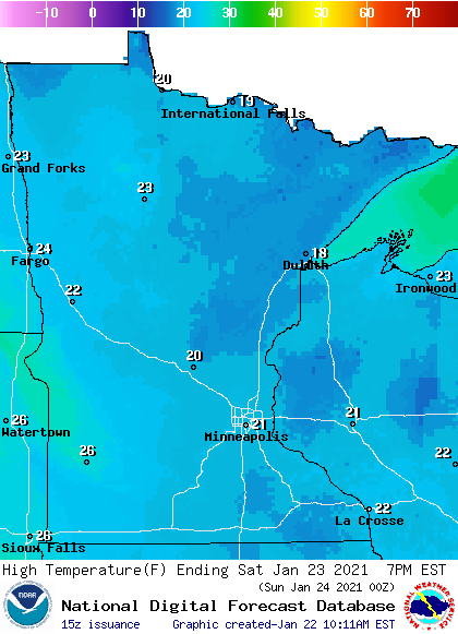
Our average Twin Cities high temperature is 24 degrees on Jan. 24. Metro area highs are expected to be in the lower 20s this Saturday. Highs in the 20s are expected most of Minnesota and western Wisconsin, with some teens in northeastern Minnesota:

rt0123h2
Saturday forecast highs
National Weather Service

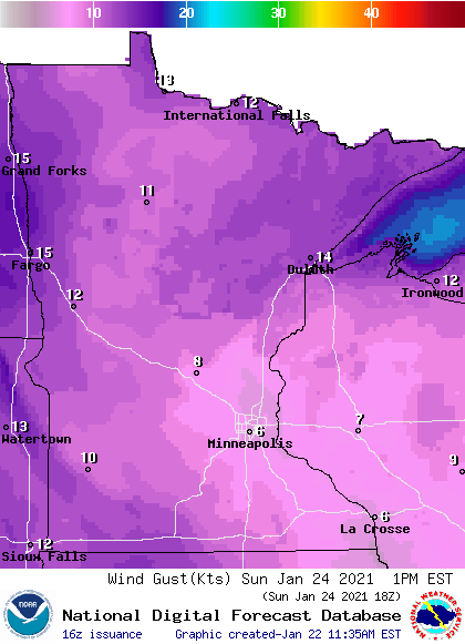
Saturday wind gusts are expected to be in the 12-17 mph range in most areas, but wind gusts could top 20 mph in parts of southwestern Minnesota and far northwestern Minnesota:

rt0123g2
Saturday noon forecast wind gusts
National Weather Service

Plotted gusts are in knots, with 14 knots equal to 16 mph.

Back to temperatures, Sunday highs will reach the 20s in the southern half of Minnesota plus western Wisconsin:

rt0124h2
Sunday forecast highs
National Weather Service

Sunday highs will be in the teens in much of northern Minnesota, with single-digit highs in parts of northwestern Minnesota.

Sunday wind gusts are expected to be in the 8 mph to 12 mph range in most areas:

rt0124g2
Sunday noon forecast wind gusts
National Weather Service

Winds will be gusting over 14 mph in parts of northern Minnesota on Sunday.

Programming note

You can hear my live weather updates on MPR News at 7:35 a.m., 9:35 a.m. and 4:39 p.m. each Saturday and Sunday.