Originally published February 20th, 2022 4:18 p.m.
Updated February 21st, 2022 5:50 a.m.
(KNSI) — A winter storm warning is now in effect until 6:00 p.m. Tuesday.
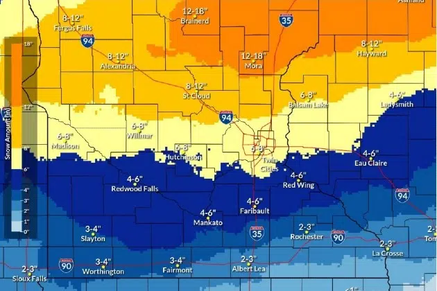
Some of the higher snow totals have moved north, but the St. Cloud area could still see between eight and 12 inches of snow by the time it is all said and done Tuesday night.
A long-duration snowfall event will cause major travel headaches as the snow is expected to move through the area in two waves. The heaviest snow is expected to fall in an east-west line across central Minnesota through Monday afternoon but diminishes late Monday night. Areas from Alexandria through St. Cloud and over to Mora could see an additional four to eight inches of snow. Gusty northeast winds at 20 to 25 miles an hour with gusts around 30 will cause areas of blowing and drifting as the snow with this system will be lighter and fluffier.
Snow will become more widespread late Monday night and into Tuesday as the system broadens out and exits the region late Tuesday night. An additional four to six inches of snow are possible around St. Cloud, with six to eight inches not out of the question to the east of St. Cloud.
Winds Tuesday won’t be quite as strong, coming out of the north at 15 to 25 miles an hour, switching to the northwest Tuesday evening. Arctic cold wraps in behind the snow, with temps below zero Tuesday night and windchills around 25 degrees below zero.
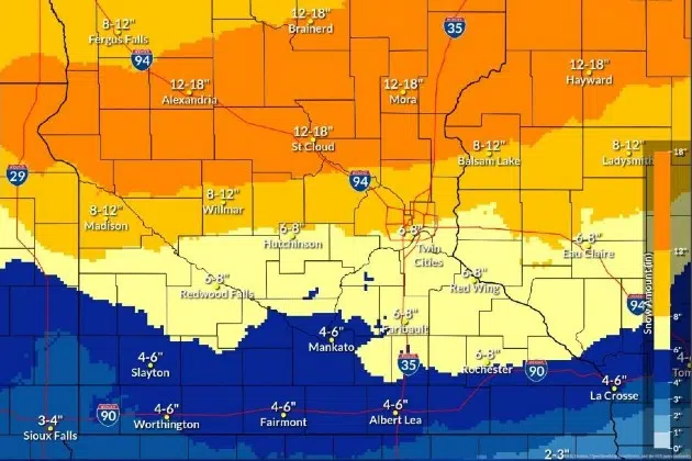
National Weather Service forecast model showing higher snow totals for the Sunday afternoon update.
___
Copyright 2022 Leighton Enterprises, Inc. All rights reserved. This material may not be broadcast, published, redistributed, or rewritten, in any way without consent.


FOLLOW US FOR INSTANT UPDATES!


FOLLOW US FOR INSTANT UPDATES!